Wednesday, June 30, 2010
Lab 2a: Google Maps
View Surfing LA in a larger map
Neogeography is a term used to describe a new type of geography that allows people to create their own maps from existing ones simply by using an existing toolset. There are several pros and cons in neogeography. The ability for a user to create his/her own map allows for the personalization of maps. In a relatively short amount of time someone can create a map that shows all of their favorite places such as restaurants. This can then be shared with others. Neogeography allows for an exchange of information through personal maps in a short amount of time. If someone wants to give a group of people directions somewhere they can make a personal map and post it on the web.
Personalized maps can be very useful but neogeography has it's cons as well. The spread of personal information through neogeography could fall in the hands of the wrong person and lead to fraud or other illegal activities. Although neogeography creates some useful maps, these user generated maps are not always correct and the circulation of incorrect maps on the internet is a posibility. This is comparable to websites such as wikipedia which offers a wealth of information but isn't always correct. Personal maps are usually not suitable for research and do not convey vast amounts of information like the USGS topographic maps do. Neogeographic maps are similar to mental maps and therefore are one persons creation, not a standard to be used by everyone.
Monday, June 28, 2010
Lab 1b: USGS Topographic maps
1. What is the name of the quadrangle? Beverly Hills Quadrangle California 7.5-Minute Series (Topographic)
2. What are the names of the adjacent quadrangles? Canoga Park, Van Nuys, Burbank, Topanga, Hollywood, Venice, Inglewood
3. When was the quadrangle first created? 1966
4. What datum was used to create your map? Metadata
5. What is the scale of the map? 1:24,000
6. At the above scale, answer the following:
a) 5 centimeters on the map is equivalent to how many meters on the ground? 1200
b) 5 inches on the map is equivalent to how many miles on the ground? 1.89 miles
c) one mile on the ground is equivalent to how many inches on the map? .0000416
d) three kilometers on the ground is equivalent to how many centimeters on the map? 12.5
7. What is the contour interval on your map?
20 ft
8. What are the approximate geographic coordinates in both degrees/minutes/seconds and
decimal degrees of:
a) the Public Affairs Building? Lat: 34.07422 Long: -118.44016 Lat: 34,4’,27.2”
Long: -118,26’,24.6”
b) the tip of Santa Monica pier? Lat: 34.00768 Long: -118.49967 Lat: 34,0’,27.7”
Long: -118,29’,58.8”
c) the Upper Franklin Canyon Reservoir? Lat: 34.12099 Long: -118.49967 Lat: 34,7’,15.6”
Long: -118,27’,19.6”
9. What is the approximate elevation in both feet and meters of:
a) Greystone Mansion (in Greystone Park)? 600ft 182.88 m
b) Woodlawn Cemetery? 140ft 42.672 m
c) Crestwood Hills Park? 700ft 213.35 m
10. What is the UTM zone of the map? 11
11. What are the UTM coordinates for the lower left corner of your map?34,1’,18”
12. How many square meters are contained within each cell (square) of the UTM gridlines? 1,000m2
13. Obtain elevation measurements, from west to east along the UTM northing 3771000,
where the eastings of the UTM grid intersect the northing. Create an elevation profile
using these measurements in Excel (hint: create a line chart). Figure out how to label
the elevation values to the two measurements on campus. Insert your elevation profile
as a graphic in your blog.

14. What is the magnetic declination of the map? 13,12’
15. In which direction does water flow in the intermittent stream between the 405 freeway
and Stone Canyon Reservoir? From North to South
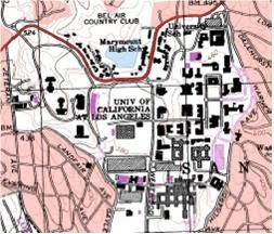
16. Crop out (i.e., cut and paste) UCLA from the map and include it as a graphic on your
blog.
Wednesday, June 23, 2010
3 Maps
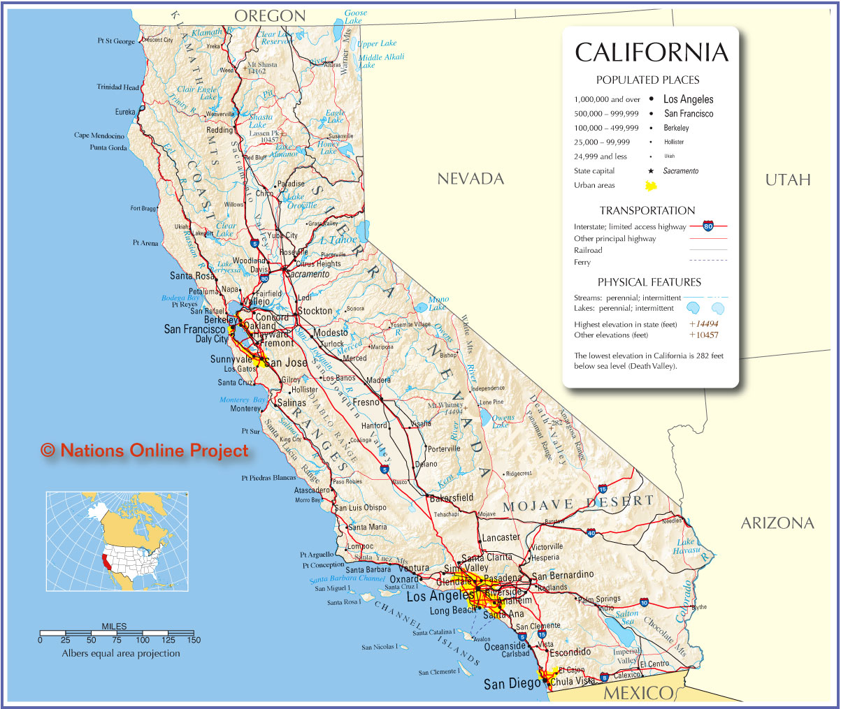 This map is from the website: http://jdrhs69.org/map_files/map_images/California_map.jpg. The website is:

THE OFFICIAL WEBSITE OF THE JONATHAN DAYTON REGIONAL HIGH SCHOOL CLASS OF 1969
This is a map of the state of California. It shows all of the major cities and the freeways that connect them. The map also includes the most prominent features in California such as mountains, lakes, rivers, bays, and valleys.
I find this map interesting because I am very connected with California, it's cities, and of course it's freeways. I travel on California's freeways every week and it is interesting to see how they connect all of the major cities together. I like seeing all the places I have been and the places I want to go. It is interesting to compare my mental map of California with the actual map.

This map is from a BBC news article about the 2010 World Cup from the website: http://news.bbc.co.uk/1/hi/8140433.stm.
The map shows the locations for all of the stadiums that will be used in the World Cup this year in South Africa.
The map is interesting because it is very simple. It shows no roads or major landmarks other than a lake that isn't labeled. The map does give a general idea of where the soccer stadiums are, how far apart they are, and whether they are preexisting or built specifically for the World Cup. I like the map because it gives me a general idea of where the stadiums are and it is easy to read. As a map that is intended for fans not familiar with South Africa, I think it's simplicity is good because the map is just meant to give fans an idea of where the stadiums are located throughout South Africa.
 This map is from a website titled "WannaSurf". It is a website that shows where surf spots are and includes some information about them such as wave type and crowd type. The website is: http://www.wannasurf.com/spot/North_America/USA/California/San_Diego_County/.
The map shows all of the major surf spots in San Diego county.
The map is interesting because it really highlights the number of places there are to surf in San Diego. It is a unique map catered solely to surfers. The map is also interactive on the website so you can zoom in or out. The fact that the map is interactive is one of its most interesting features. Maps that can zoom in and out help me to get an idea of where the general location of a beach is as well as the specific location of the surf spot at that beach. The interactive map also has roads and freeways which gives good reference points.

Subscribe to:
Posts (Atom)